Distinctive Features of Coastal Washington
The single biggest feature of Coastal Washington is Olympic National Park, which is home to four temperate rain forests (Hoh, Quinault, Queets and Bogchiel) getting around 140 inches of rain annually.
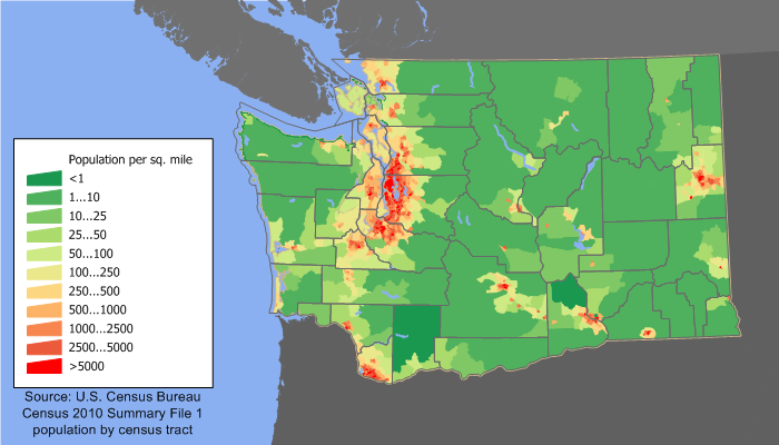 Although there are no big cities in the region, the population densities of some of the small towns that ring the park are as high as some of the big cities on the eastern side of Puget Sound. The park is both a national treasure and a logistical challenge for developing the region.
Copalis State Airport is notable for being the only airport in Washington State where landing on the beach is legal.
The Hoh is the wettest forest in the contiguous United States.
Olympic National Park
Much of the big green area -- i.e. unpopulated area -- in the northern part of the Coastal Washington region on this Wikimedia map is Olympic National Park. This is preserved land that cannot be developed.
In 1976, Olympic National Park was designated by UNESCO as an International Biosphere Reserve, and in 1981 as a World Heritage Site... It is the largest wilderness area in Washington.It is open 24 hours a day and gets about 2.5 million visitors annually. Multiple towns in the area promote themselves as "the gateway to the Olympics".
In 2014, the world’s largest dam removal took place in Olympic National Park. Two major dams were removed as part of the Elwha River Restoration project.
Quinault Indian Nation
These Native Americans are doing better than many tribes within the borders of the United States because they took control of their lives to the best of their ability as part of a pilot project decades ago. They have a lodge that visitors can stay in and they do substantial business with surrounding communties, including having a Q-mart in Aberdeen.The Self-Governance Act of 1988 began as a demonstration project in the Bureau of Indian Affairs (BIA). In 1990, we took the challenge, along with six other tribes, to implement self-rule in Indian affairs.Their land sits along the Pacific Coast west of Olympic National Park. Between the park and Quinault Indian Nation, the majority of the center and parts of the Pacific Coast are preserved lands. The remaining area that can be developed is in sort of a hook shape.
PNNL-Sequim
There are only seventeen national laboratories in the United States. Washington state is fortunate to be the location of one of them, the Pacific Northwest National Laboratory. It is headquartered in The Tri-Cities (Richland-Pasco-Kennewick) in southeastern Washington but it has a satellite office in Sequim doing marine research due to the unique marine environment there.Aberdeen
Aberdeen is just 17,000 people but was once known as The Lumber Capital of the World. At that time, it was quite wealthy, which has left the downtown with a rich heritage of valuable infrastructure and it remains the commercial hub for the region giving it an unusually high commercial service level for a town of this size.Port of Grays Harbor
This is a deep water port with the distinction of being a day closer to Asia than any other deep water port on the West Coast of the US. This is potentially significant if you wish to do business that involves importing anything from or exporting anything to Asia.Copalis State Airport
At first blush, Coastal Washington seems to have an unusual number of airports and landing strips for a semi-rural region full of small towns. This may be due to the barrier to travel presented by Olympic National Park and the Quinault Indian Nation.Copalis State Airport is notable for being the only airport in Washington State where landing on the beach is legal.